Geotile grid aggregation
editGeotile grid aggregation
editA multi-bucket aggregation that groups geo_point and
geo_shape values into buckets that represent a grid.
The resulting grid can be sparse and only
contains cells that have matching data. Each cell corresponds to a
map tile as used by many online map
sites. Each cell is labeled using a "{zoom}/{x}/{y}" format, where zoom is equal
to the user-specified precision.
- High precision keys have a larger range for x and y, and represent tiles that cover only a small area.
- Low precision keys have a smaller range for x and y, and represent tiles that each cover a large area.
See Zoom level documentation on how precision (zoom) correlates to size on the ground. Precision for this aggregation can be between 0 and 29, inclusive.
The highest-precision geotile of length 29 produces cells that cover less than a 10cm by 10cm of land and so high-precision requests can be very costly in terms of RAM and result sizes. Please see the example below on how to first filter the aggregation to a smaller geographic area before requesting high-levels of detail.
You can only use geotile_grid to aggregate an explicitly mapped geo_point or
geo_shape field. If the geo_point field contains an array, geotile_grid
aggregates all the array values.
Simple low-precision request
editPUT /museums
{
"mappings": {
"properties": {
"location": {
"type": "geo_point"
}
}
}
}
POST /museums/_bulk?refresh
{"index":{"_id":1}}
{"location": "52.374081,4.912350", "name": "NEMO Science Museum"}
{"index":{"_id":2}}
{"location": "52.369219,4.901618", "name": "Museum Het Rembrandthuis"}
{"index":{"_id":3}}
{"location": "52.371667,4.914722", "name": "Nederlands Scheepvaartmuseum"}
{"index":{"_id":4}}
{"location": "51.222900,4.405200", "name": "Letterenhuis"}
{"index":{"_id":5}}
{"location": "48.861111,2.336389", "name": "Musée du Louvre"}
{"index":{"_id":6}}
{"location": "48.860000,2.327000", "name": "Musée d'Orsay"}
POST /museums/_search?size=0
{
"aggregations": {
"large-grid": {
"geotile_grid": {
"field": "location",
"precision": 8
}
}
}
}
Response:
{
  ...
  "aggregations": {
    "large-grid": {
      "buckets": [
        {
          "key": "8/131/84",
          "doc_count": 3
        },
        {
          "key": "8/129/88",
          "doc_count": 2
        },
        {
          "key": "8/131/85",
          "doc_count": 1
        }
      ]
    }
  }
}
High-precision requests
editWhen requesting detailed buckets (typically for displaying a "zoomed in" map) a filter like geo_bounding_box should be applied to narrow the subject area otherwise potentially millions of buckets will be created and returned.
POST /museums/_search?size=0
{
  "aggregations": {
    "zoomed-in": {
      "filter": {
        "geo_bounding_box": {
          "location": {
            "top_left": "52.4, 4.9",
            "bottom_right": "52.3, 5.0"
          }
        }
      },
      "aggregations": {
        "zoom1": {
          "geotile_grid": {
            "field": "location",
            "precision": 22
          }
        }
      }
    }
  }
}
{
  ...
  "aggregations": {
    "zoomed-in": {
      "doc_count": 3,
      "zoom1": {
        "buckets": [
          {
            "key": "22/2154412/1378379",
            "doc_count": 1
          },
          {
            "key": "22/2154385/1378332",
            "doc_count": 1
          },
          {
            "key": "22/2154259/1378425",
            "doc_count": 1
          }
        ]
      }
    }
  }
}
Requests with additional bounding box filtering
editThe geotile_grid aggregation supports an optional bounds parameter
that restricts the cells considered to those that intersects the
bounds provided. The bounds parameter accepts the bounding box in
all the same accepted formats of the
bounds specified in the Geo Bounding Box Query. This bounding box can be used with or
without an additional geo_bounding_box query for filtering the points prior to aggregating.
It is an independent bounding box that can intersect with, be equal to, or be disjoint
to any additional geo_bounding_box queries defined in the context of the aggregation.
POST /museums/_search?size=0
{
  "aggregations": {
    "tiles-in-bounds": {
      "geotile_grid": {
        "field": "location",
        "precision": 22,
        "bounds": {
          "top_left": "52.4, 4.9",
          "bottom_right": "52.3, 5.0"
        }
      }
    }
  }
}
{
  ...
  "aggregations": {
    "tiles-in-bounds": {
      "buckets": [
        {
          "key": "22/2154412/1378379",
          "doc_count": 1
        },
        {
          "key": "22/2154385/1378332",
          "doc_count": 1
        },
        {
          "key": "22/2154259/1378425",
          "doc_count": 1
        }
      ]
    }
  }
}
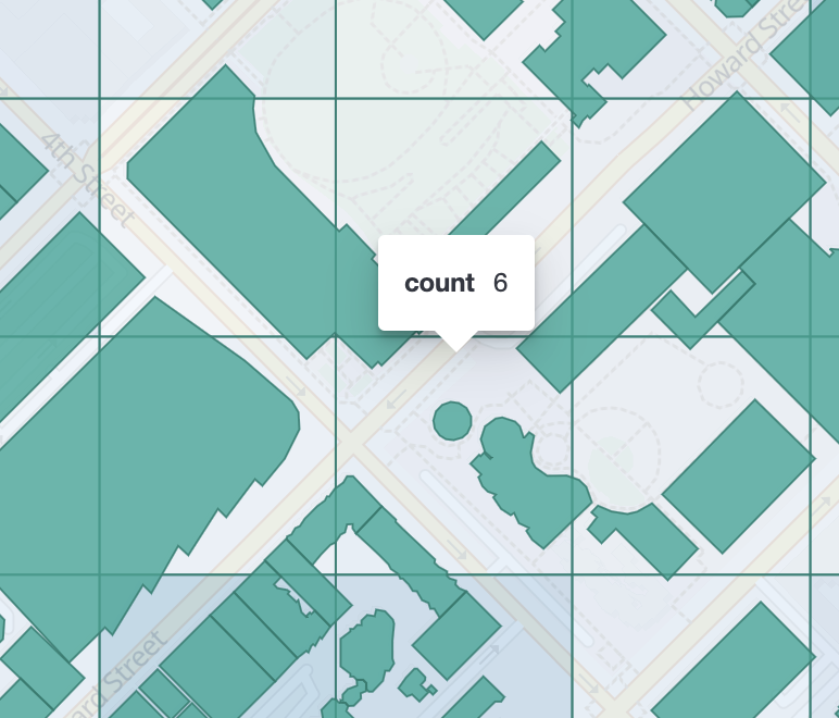
Aggregating geo_shape fields
editAggregating on Geoshape fields works just as it does for points, except that a single shape can be counted for in multiple tiles. A shape will contribute to the count of matching values if any part of its shape intersects with that tile. Below is an image that demonstrates this:
Options
edit|
field |
Mandatory. The name of the field indexed with GeoPoints. |
|
precision |
Optional. The integer zoom of the key used to define cells/buckets in the results. Defaults to 7. Values outside of [0,29] will be rejected. |
bounds: Optional. The bounding box to filter the points in the bucket.
- size
- Optional. The maximum number of geohash buckets to return (defaults to 10,000). When results are trimmed, buckets are prioritised based on the volumes of documents they contain.
- shard_size
-
Optional. To allow for more accurate counting of the top cells
returned in the final result the aggregation defaults to
returning
max(10,(size x number-of-shards))buckets from each shard. If this heuristic is undesirable, the number considered from each shard can be over-ridden using this parameter.